
Civil War & Others

Lloyd Clayton Flynt
The Navy Cross Citation Plaque was awarded during World War II for Extraordinary Heroism on October 25, 1944.
_edited.jpg)
Ralph Atkinson and 42nd Division
The Distinguished Service Plaque of World War I commemorates the extraordinary heroism displayed in October of 1918.

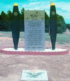
Robert Hite and Doolittle Raiders Plaque
This plaque commemorates the heroic “Doolittle Raiders” who bombed Japan at the outset of World War II, as well as Robert Hite, Camden’s native son who survived the raid and forty months of imprisonment to return a hero in 1945.
_JPG.jpg)
Solie Solomon (Lee Kendall)
Distinguished Flying Cross Recipient Plaque
Solomon’s August 1945 action near Japan was likely the last aerial action in World War II.
Ira H. Nunn Navy Cross Citation
Ira H. Nunn was the Navy Commander and Rear Admiral of the Asiatic Fleet, as well as a descendant of early settler John Nunn.


Camden Water Battery Civil War 1864 Plaque
Located near the Sandy Beach gazebo on the Ouachita River bank and near the earthen entrenchments erected in 1864, it served as a defense against a possible Union advance. It is located on the driveway turning off East Washington to Sandy Beach Park in front of the gazebo.

Civil War Union Army 1864
Pontoon Bridge Plaque
The plaque is located near the spot where the Union Army of Frederick Steele placed an India Rubber Pontoon Bridge to facilitate nighttime evacuation of Camden. This occurred when the Federal plans of the Red River Campaign unraveled. The marker narrates the subsequent story of the harrowing retreat that included the Battle of Jenkins Ferry and its frightful cost to both sides. It is located on the South side of State Hwy. 7 North, which turns west off Business U.S. 79 just past the Ouachita River bridge.

Fort Lookout Redoubt A 1863 Plaque
A National Landmark, it's one of nine fortifications built by Confederates in 1863 - 1864 to defend from possible Union advances from the north and west. It commanded a panoramic view of the Ouachita River and was later used by Federals during brief 1864 occupation. Future Visitor Center for heritage tours following Red River campaign. It is located on Rogers St. near the intersection at Monroe St. NE.
Redoubt B 1863 Plaque
The Redoubt B is the approximate location of the fortification constructed in 1863 - 1864 along a ridge to protect Camden from enemies approaching from the Tate’s Bluff and Washington Road area. It is located on the SW corner of Maul Rd. and Greenwood Avenue, on the corner of Greenwood Cemetery grounds.


Fort Simmons Redoubt C 1863 Plaque
One of the nine civil war fortifications in Camden. This site is named after W.R. “Pap” Simmons, a local tin smith who lived nearby. Remains of the fort are lost, but the marker is in the general vicinity. It is located on NW corner of McCullough and Cleveland Ave. NW.

Fort Southerland Redoubt D
1863 – 1864
In its time it was the largest of nine Confederate Civil War fortifications. Located on one of the highest points in town, it commanded entrance into the city from south and west. The excavated dirt was used to build other forts. The marker is on California Ave. SW facing the entrance to Center St., but the actual site of the fort is on the south side of Chestnut St. at the crest of the hill on the first block, on private property.
1944 Military Plane Crash Monument
This monument was placed in honor of 8 brave men that gave their lives at a crash site near this place during WWII. It is located beside the French Port water tower, which is 6 miles south along Hwy 7 from Fairview Rd. The monument is on the south east corner of Arkansas Hwy 7 S and Ouachita 64 Rd.

Poison Spring Battlefield
The State Park interprets the Civil War Battle at Poison Spring, April 18, 1864, a key engagement in the Camden Expedition segment of the Union forces ill-fated Red River Campaign. It was the major military event near Camden and involved participation of Choctaw Indians and the First Kansas Colored Infantry. In April on even numbered years a battle reenactment is conducted at the old battle site in the State Park grounds.
_j.jpg)
First Kansas Colored Infantry Plaque
It is located just north of Bragg Lake facing Arkansas State Highway 24 and commemorates the first African American regiment recruited in the Civil War and the first to see combat. Their service brought them into the battle of Poison Springs fought near here in April 1864 where, insignificant fighting, they suffered high casualties and their wounded were brutally slain afterward as they lay on the battlefield.

Tate’s Bluff Civil War Marker
Because of its strategic location on high ground overlooking the confluence of the Ouachita and Little Missouri Rivers, Tate’s Bluff was utilized by Confederates during the war as an observation post and as a point for gathering troops. Although a small fort was built nearby, no action took place here. It is located on the west side of County Road 25 just south of the Ouachita River Bridge.
War Monument Marker
This marker honors all county residents who served and/or gave their lives for their country in World War I, World War II, the Korean War and the Vietnam War. It also honors the prisoners of war in World War II and the Korean War.

Nearby Smaller Markers
This particular marker honors all county residents who served their country in World War I, World War II, the Korean War and the Vietnam War. This marker was donated by the Gifted & Talented Class of Fairview School in l987-1988.
_.jpg)
The Spanish-American War Monument
This monument is dedicated to the memory of the veterans from the Spanish American War of 1898 – 1902.


Monument to Honor Confederate Women
The largest monument at the courthouse (located in the center of the northwest quadrant of the grounds) was erected in 1914 to honor the women of the Confederacy for their care of wounded soldiers and for steadfastly tending the home front. It was provided by the Hugh McCollum Camp 778 of the United Confederate Veterans with the aid of the Grinstead Chapter of the United Daughters of the Confederacy. The monument withstood the tornado of 1931, which destroyed the courthouse building.

Artis Breland Jr.
Honors Recipient of the Distinguished Service Plaque for Extraordinary Heroism during military operations in the Vietnam War.

Fort Diamond Redoubt E 1863 Plaque
Diamond shape Civil War fortification built by Confederates in l863 to1864 to defend against possible Union advances from south and east and later used by Federals during brief occupation of Camden in spring of 1864. Mistaken references in earlier years confused this fortification with Ft. Southerland located west of here and that misnomer still appears in some designations. Plaque is located at the corner of Bradley Ferry Rd. and Progress St. at the foot of a prominent hill and former fortification. Bradley Ferry Rd. intersects US 79-278 bypass at the current traffic light.